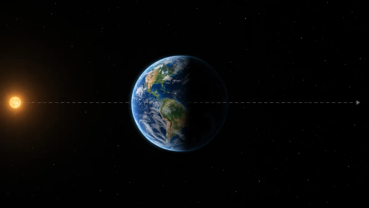
The antisolar point is the direction opposite the Sun as seen from Earth. SETI researchers are testing it as a possible rendezvous direction for radio communication; their pilot found no technosignatures. The SETI Institute’s announcement of November 3 supplies the research context.
For Solar System Live readers, the useful starting question is surprisingly practical: where would you draw that direction on the planetary scene? Our exercise connects the news to the Earth and Sun you explore here, without turning a simulated view into an alien-signal detector.
How can I locate it in the simulator?
Find Earth and the Sun in Solar System Live. Make a simple sketch beside the screen, identifying both before adding anything else. Use this sequence:
1. Put your imaginary observer at Earth. 2. Draw an arrow from Earth towards the Sun. 3. Add a second arrow pointing the other way. 4. Label that second arrow “search direction”, leaving its far end open.
This is a drawing exercise based on the definition above, not a measurement of the telescope’s pointing. There is no need to invent a distant planet to complete it.
The important choice is where you place the observer. Before interpreting any arrow on your sketch, ask: “Whose sky does this represent?”

Why might anyone choose that direction?
The researchers connect the alignment with Earth transiting the Sun for a suitably placed distant observer. Game theory supplies the coordination idea: two parties might independently choose a recognisable reference without arranging it beforehand. That is a hypothesis about a sender’s choices. The institute explains the reasoning.
Try adding a hypothetical observer to your sketch, explicitly labelling it “assumed”. Then distinguish the things you drew because they define the geometry from the things you supplied to imagine communication.
That distinction gives you a useful way to read the proposal: which part can I represent, and which part would require evidence?
Is this the same thing as Webb’s L2?
No. NASA describes Webb’s observing region near Sun–Earth L2, beyond Earth away from the Sun, and its halo orbit around that region. L2 identifies a location in an orbital arrangement; the antisolar point identifies a sky direction. Compare NASA’s Webb orbit explanation with the SETI definition above.
Our [guide to Webb at L2](/articulos/webb-l2-orbita-alrededor-sol/) makes a useful companion exercise. Draw a location marker and a direction arrow using different symbols. Do not let the word “point” make them interchangeable.
What should I record beside the scene?
This is our Solar System Live worksheet, not an observing log or a table of newly measured signals.
| Part of your exercise | What to record | Question before drawing a conclusion | |---|---|---| | Earth and Sun | Labelled reference bodies | Have I identified both correctly? | | Imaginary observer | The viewpoint I chose | Am I switching viewpoints unnoticed? | | Search arrow | A direction, with no invented destination | Have I accidentally drawn a discovered object? | | Hypothetical sender | An explicit assumption | What evidence would establish its existence? | | Research result | The finding stated by its source | Am I confusing a proposal with a detection? |
For help with that final distinction, continue to our [guide to astronomical images and simulations](/articulos/foto-agujero-negro-real-o-simulacion/).
What can I do next?
Open Solar System Live and complete the sketch. Give it this caption: “A geometric explanation of a search direction.” Then write a separate sentence about the reported result.
Keeping those captions separate is the exercise’s payoff: you can explain where researchers are looking without claiming that the screen—or the search—has revealed someone there.